Walk Best Site
I can be contacted at E-mail address:-
![]()
Walk Best SiteI can be contacted at E-mail address:-
|
|
|
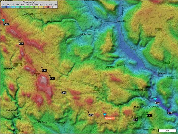
Walk best Repeater site:- Derby Raynet run Emergency Communications Exercises to support Charity Events in the (UK) Derbyshire Peak District. The map shows checkpoint locations for an annual 'British Heart Foundation' 18 mile Winter Challenge Walk. Sponsored Entrants for the Nov. 2004 event number 1500, with Raynet required to provide communications from the control point to Emergency vehicles, Check Points, and also the Transport fleet. The original Repeater station had been located by choosing high ground from a map and producing paper path profiles, but access to the site was via two miles of farm tracks and open moorland! Site access problems with a 4x4, due to the November weather, prompted a search for a more accessible Repeater site. This became possible using Radio Mobile when the 3 arc-second elevation dataset for the UK was released on the 1st November 2003!
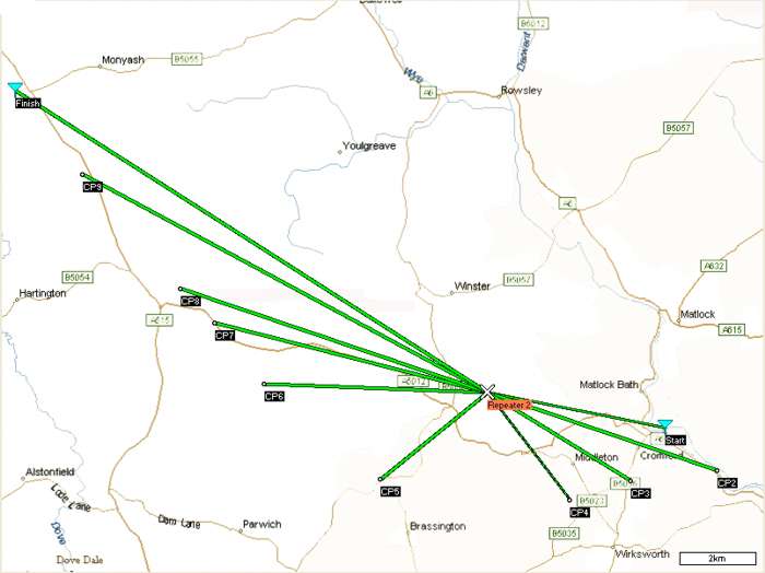
Results : A new repeater location location was found on the elevation map (with roads merged), by using a 'Move and Test' procedure. A click on the map at a proposed position to produce the Cursor, followed by 'right click' on the Repeater to select 'Move unit to Cursor Position' produced the relocation. A click on the 'Show Networks' button then produced graphical evidence of signal paths for all the Links enabled. This procedure was then repeated to find a 'good' location for the repeater near a road for access. The resulting 'Repeater 2' site with its network are shown below :-
Detailed analysis of the signal paths showed improvements to all check points, with CP4 being worst at S3. This site was used for the 2003 event where the predictions were confirmed in practice! Access to the roadside site via Farm roads was a great benefit, reducing system setup time.
Just after this event, the Find Best Sites feature was added to Radio Mobile by Roger. which simplified the placing of these stations!
The continuing work on Radio Mobile has made the preliminary planning of these events possible, and reduced the checking of site locations to a mornings work!
To see more screenshots produced by the program, look at RM Screenshots
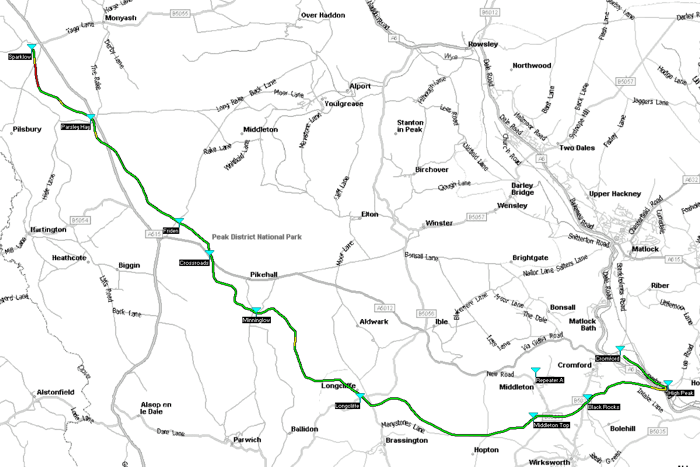
An additional 'Route' feature has been added to the program which eases the procedure of checking radio paths along a defined route. See below for all the Links!
The picture below shows the actual Route taken by the walkers. The colour of the plot gives an indication of the Radio Performance from the new Repeater A location to a Hand Held radio unit traversing it.
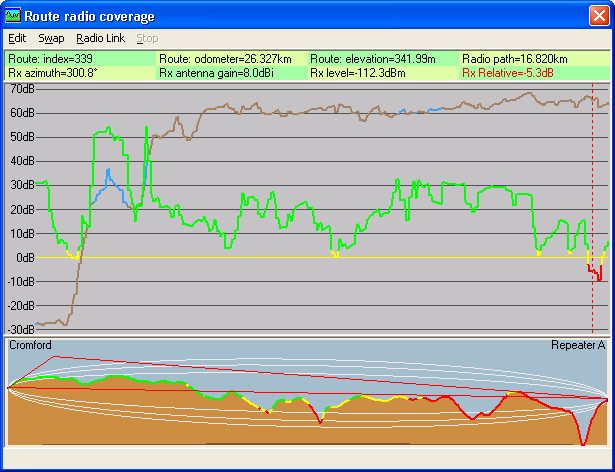
Detail of the Route Performance, in the linear plot below, gives details of the signal levels and radio path between the selected Units. The background Elevation plot is Brown, changing to Blue where a 'Line of sight path' exists between the Units.
The actual performance of the link at the cursor location is indicated in the top data area, with the radio link and Route being displayed on the main map. To gain additional information the 'Radio Link' pane can be opened.
For more information see :-
This page is available in .pdf format here
Please keep checking back for updates/additions.
Don't forget the Handbooks
© Copyright G3TVU 1st February 2016
|